There is a world somewhere between reality and fiction. Although ignored by many, it is very real and so are those living in it. This forum is about the natural world. Here, wild animals will be heard and respected. The forum offers a glimpse into an unknown world as well as a room with a view on the present and the future. Anyone able to speak on behalf of those living in the emerald forest and the deep blue sea is invited to join.
05-19-2019, 08:05 AM( This post was last modified: 05-30-2019, 07:19 AM by Rishi )
After years of unconfirmed sighting & reports of tiger presence in Goa, 2013 saw a tigres camera-trapped in Mhadei Sanctuary of the tiny state sandwiched in between Maharastra & Karnataka. After which the presence of the same tigress was repeatedly captured on camera for successive years.
A proposed tiger reserve, was approved by Goa state wildlife advisory board in 2017, by including core areas of Mhadei and Mahavir sanctuaries along with the Mollem national park. This can be an important key in establishing a successful Sahyadri-Konkan wildlife corridor along the length of the Western Ghat.
05-23-2019, 08:45 AM( This post was last modified: 05-30-2019, 07:20 AM by Rishi )
(05-19-2019, 08:05 AM)Rishi Wrote: After years of unconfirmed sighting & reports of tiger presence in Goa, 2013 saw a tigres camera-trapped in Mhadei Sanctuary of the tiny state sandwiched in between Maharastra & Karnataka. After which the presence of the same tigress was repeatedly captured on camera for successive years.
A proposed tiger reserve, was approved by Goa state wildlife advisory board in 2017, by including core areas of Mhadei and Mahavir sanctuaries along with the Mollem national park. This can be an important key in establishing a successful Sahyadri-Konkan wildlife corridor along the length of the Western Ghat.
05-28-2019, 07:10 PM( This post was last modified: 05-28-2019, 10:46 PM by BorneanTiger )
(05-12-2016, 04:31 AM)Pckts Wrote: Southern India is one of the lesser known tiger territories when it comes to individuals, but it is still one of the richest and diverse areas in all of India.
Please share any info on tigers, terrain or other species that inhabit this beautiful place.
*This image is copyright of its original author
The Indian government declared the forests of Sathyamangalam Wildlife Sanctuary a Tiger Reserve on March 15, 2013.
*This image is copyright of its original author
This forest along the Nilgiri hill range is to serve as aprotected corridor to faculitate movements and genetic exchange between tigers from Western Ghats, Eastern Ghats and Anamalai, Cardamom hills further south.
Western Ghats
Western Ghats (also known as Sahyadri meaning The Benevolent Mountains) is a mountain range that runs parallel to the western coast of the Indian peninsula, located entirely in India. It is a UNESCOWorld Heritage Site and is one of the eight "hottest hot-spots" of biological diversity in the world.[1][2] It is sometimes called the Great Escarpment of India.[3] The range runs north to south along the western edge of the Deccan Plateau, and separates the plateau from a narrow coastal plain, called Konkan, along the Arabian Sea. A total of thirty nine properties including national parks, wildlife sanctuaries and reserve forests were designated as world heritage sites - twenty in Kerala, ten in Karnataka, five in Tamil Nadu and four in Maharashtra.[4][5]
The range starts near the border of Gujarat and Maharashtra, south of the Tapti river, and runs approximately 1,600 km (990 mi) through the states of Maharashtra, Goa, Karnataka, Kerala and Tamil Nadu ending at Kanyakumari, at the southern tip of India. These hills cover 160,000 km2 (62,000 sq mi) and form the catchment area for complex riverine drainage systems that drain almost 40% of India. The Western Ghats block southwest monsoon winds from reaching the Deccan Plateau.[6] The average elevation is around 1,200 m (3,900 ft).[7]
The area is one of the world's ten "Hottest biodiversity hotspots" and has over 7,402 species of flowering plants, 1,814 species of non-flowering plants, 139 mammal species, 508 bird species, 179 amphibian species, 6,000 insects species and 290 freshwater fish species; it is likely that many undiscovered species live in the Western Ghats. At least 325 globally threatened species occur in the Western Ghats.[8][9][10]
The Western Ghats are the mountainous faulted and eroded edge of the Deccan Plateau. Geologic evidence indicates that they were formed during the break-up of the supercontinent of Gondwana some 150 million years ago. Geophysical evidence indicates that the west coast of India came into being somewhere around 100 to 80 mya after it broke away from Madagascar. After the break-up, the western coast of India would have appeared as an abrupt cliff some 1,000 m (3,300 ft) in elevation.[11]Basalt is the predominant rock found in the hills reaching a thickness of 3 km (2 mi). Other rock types found are charnockites, granite gneiss, khondalites, leptynites, metamorphic gneisses with detached occurrences of crystalline limestone, iron ore, dolerites and anorthosites. Residual laterite and bauxite ores are also found in the southern hills.
The Western Ghats extend from the Satpura Range in the north, stretching from Gujarat to Tamil Nadu. It traverses south past the states of Maharashtra, Goa, Karnataka and Kerala. Major gaps in the range are the Goa Gap, between the Maharashtra and Karnataka sections, and the Palghat Gap on the Tamil Nadu and Kerala border between the Nilgiri Hills and the Anaimalai Hills. The mountains intercept the rain-bearing westerly monsoon winds, and are consequently an area of high rainfall, particularly on their western side. The dense forests also contribute to the precipitation of the area by acting as a substrate for condensation of moist rising orographic winds from the sea, and releasing much of the moisture back into the air via transpiration, allowing it to later condense and fall again as rain.
The northern portion of the narrow coastal plain between the Western Ghats and the Arabian Sea is known as the Konkan, the central portion is called Kanara and the southern portion is called Malabar. The foothill region east of the Ghats in Maharashtra is known as Desh, while the eastern foothills of the central Karnataka state is known as Malenadu.[12] The range is known as Sahyadri in Maharashtra and Karnataka. The Western Ghats meets the Eastern Ghats at Nilgiris in northwestern Tamil Nadu. Nilgiris connects Biligiriranga Hills in southeastern Karnataka with the Shevaroys and Tirumala hills. South of the Palghat Gap are the Anamala Hills, located in western Tamil Nadu and Kerala with smaller ranges further south, including the Cardamom Hills, then Aryankavu pass, Aralvaimozhi pass near Kanyakumari. In the southern part of the range is Anamudi (2,695 metres (8,842 ft)), the highest peak in Western Ghats.
The evergreen forests in Wayanad mark the transition zone between the northern and southern ecologic regions of the Western Ghats. The southern ecologic regions are generally wetter and more species-rich. At lower elevations are the South Western Ghats moist deciduous forests, with Cullenia the characteristic tree genus, accompanied by teak, dipterocarps, and other trees. The moist forests transition to the drier South Deccan Plateau dry deciduous forests, which lie in its rain shadow to the east. Above 1,000 meters are the South Western Ghats montane rain forests, also cooler and wetter than the surrounding lowland forests, and dominated by evergreen trees, although some montane grasslands and stunted forests can be found at the highest elevations. The South Western Ghats montane rain forests are the most species-rich ecologic region in peninsular India; eighty percent of the flowering plant species of the entire Western Ghats range are found in this ecologic region.
In 2006, India applied to the UNESCOMAB for the Western Ghats to be listed as a protected World Heritage Site.[31] In 2012, the following places are declared as World Heritage Sites:[32][33]
Very meticulously done as always, but the Dangs (blue) is hardly a part of the conventional Western Ghats tiger landscape (red).
*This image is copyright of its original author
Although the location is at the northern end of Western Ghats from where Vindhyachal range begins to the east, any tigers that may be here would be of central Indian decent.
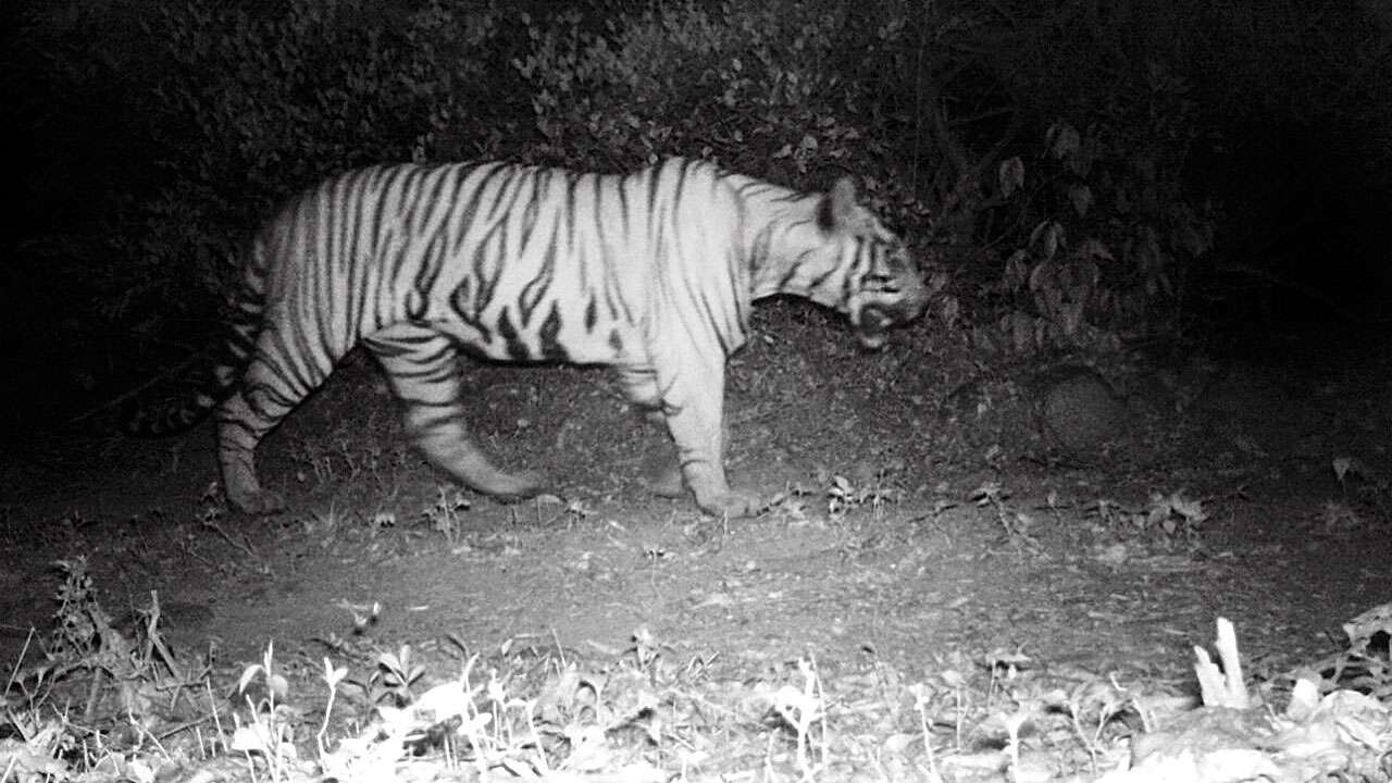
Rare camera-trap of a male at Chandoli NP, Sahyadri Tiger Reserve, published in DNA India:
*This image is copyright of its original author
Yes about that.. the Sahyadri Tiger Reserve lies exactly between Mumbai & Goa (green). It's on the narrow strip of sporadic forests to the north. Maharastra govt have been planning in 2017 to relocate surplus tigers from conflict-ridden Chandrapur area, around Tadoba (yellow) to Sahyadri... but no news made public yet.
There may be some traveling tigers coming down from the north in future, but that'd be a rare journey through a thin corridor, few hundreds km long... But there's no forest block of substantial size between Dangs & Sahyadri that can sustain any tiger population, to act as stepstone for genetic transfer.
*This image is copyright of its original author
So it's likely to be treated as a transitional area between the two populations.

 Tigers of South India & Western Ghats